Survey Equipments, Tools, Workstation & Softwares
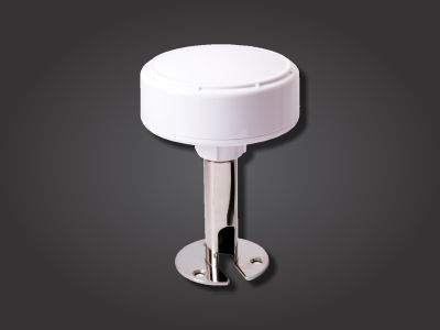
This type of DGPS is an external waterproof GPS receiver with integrated antenna for applications in the open air, at sea or on vehicles.
It has an outstanding high sensitivity Marine GPS receiver. Its excellent performance accurate, reliable and useful aid to your positioning pursuits. It also has high sensitivity for weak signal operation without compromising accuracy.
It receives FREE broadcast signals from the Low Orbit Global Positioning System (GPS), a satellite-based transmitter which emits ranging/satellite information/high precision time signals that the dgps receiver can use to determine positions and time.
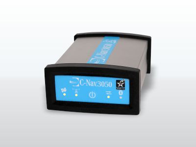
C-Nav systems deliver precise point positioning (PPP) with worldwide accuracy of better than 5 cm horizontally and 15 cm vertically. Unlike traditional DGNSS technology, our systems do not suffer from spatial decorrelation, thus providing the same accuracy anywhere in the world.
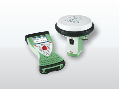
Built for harsh environmental demands, the Leica GS15 features protection against dust and water up to IP67 rating and can function even after a 2m survey pole fall or a drop to the ground of up to 1m. This reliable GNSS receiver comes with features to improve the accuracy of your data such as SmartCheck and SmartTrack and the integrated web server allows you to configure your data logging.
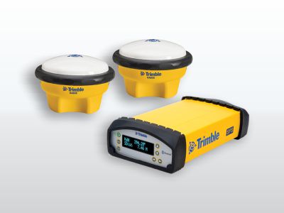
The Trimble Marine BX992 GNSS Heading Receiver is a dual-antenna GNSS receiver offering precise heading capability and and multi-frequency support for all known constellations. Additionally, with support for MSS L-Band, Marinestar or RTX services, the BX992 delivers position without the use of a base station.
The Meridian Standard provides a dynamic heading accuracy of 0.30° secant latitude RMS and a static heading accuracy of 0.10° secant latitude RMS. Whereas, the higher performance Meridian Surveyor provides a dynamic heading accuracy of 0.20° secant latitude RMS and a static heading accuracy of 0.05° secant latitude RMS.
Benefits:
• Economic one-box solution
• Fast initial settle time
• Small, lightweight and versatile
The Teledyne Dynamic Motion Sensor 500H is designed for the motion measurement needs of the marine industry. Whether it is achieving IHO standard survey from any size of vessel or providing safety critical monitoring of offshore platforms, large vessels, helicopter landing decks, cranes and positioning systems, it provides accurate motion measurement in all sea conditions.
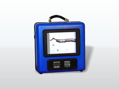
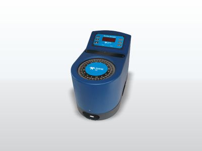
The Bathy-500HD Survey Echo Sounder provides a high-contrast thermal chart record complete with alphanumeric annotation of important parameters such as geographic position, depth, speed of sound and offset for draft/tide. Real-time viewing of all parameters is provided to the user via front panel liquid-crystal display.
Ceeducer Echosounders are high definition, high ping rate devices using traditional standard analog transducers coupled with powerful processors driving advanced bottom tracking algorithms. It is designed to give the small-boat surveyor a compact, rugged and portable “1-Box” survey solution. It is used for surveys in river, lake, port, harbour and the coastal marine environment.
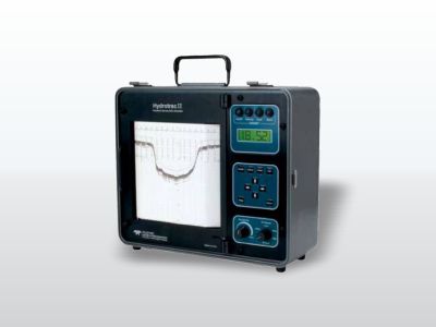
Specifically designed for work in less-than-ideal circumstances on small survey boats and inflatable watercraft, the HYDROTRAC MK-II offers compact portability and the confidence a proven product survey industry. It is completely waterproof and comes equipped with advanced features of an ideal echo sounders.
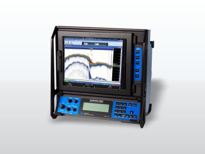
The Echotrac MK-III offers the choice of either a high-resolution thermal paper recorder or a full-sized high bright colour LCD chart in interchangeable module format. Both high and low channels feature frequency agility, enabling the operator to precisely match the transceiver to almost any existing transducer. This ability minimizes near-surface noise caused by transducer ringing while increasing echo return strength. The MK-III is capable of both shallow and deep-water operations and features unsurpassed interfacing flexibility with four serial ports and high-speed Ethernet capability for maximum efficiency.
The R2 Sonic 2020 is the low-cost entry level broadband Multibeam Echosounder for shallow, highly portable, easy to use unit makes survey operations efficient and fast. Ideal for river systems, riparian, estuaries, reservoirs, and lakes.
The Sonic 2020 can be upgraded to Ultra High Resolution (UHR), providing extremely narrow beam widths at 700kHz operation. The narrow beam widths at 700 kHz make this option invaluable for detail pipeline inspections, cable laying operations, archaeological wreck surveys or other micro bathymetry applications.
Reson 7125/7101 measures up to 511 discrete soundings equally spaced across the wide 150° swath. This sounding density combined with real-time roll stabilisation, high accuracy and robust bottom detect provides maximum performance and efficiency in all acoustic environments.
Ideal for underwater vehicles or rapid deployment onto survey craft, Flexible upgrade options for increased efficiency, Wide swath coverage of 150° to a maximum range of 500m to reduce survey time, Optional 210° swath, Water column data.
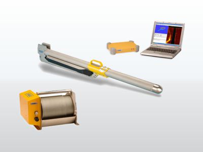
The CM2 digital towfish is the instrument that acquires the data from which the sonar image is derived. It is towed, and provided with power and digital telemetry services, by a reinforced or armoured 2-conductor tow cable.
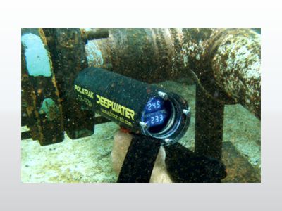
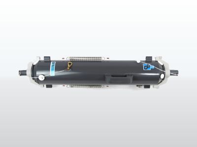
The CP Gun outperforms all other available bathycorrometer type devices in both accuracy and convenience. Longer battery life, interchangeable freshwater / seawater electrodes and ultra-bright LED displays (for limited-visibility conditions) make the CP Gun the most user-friendly diver-held CP probe. The dual-electrode elements and readouts coupled with a self-calibration capability make it the most accurate unit offered.
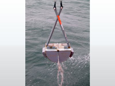
Grab Samplers are one of the most common methods of retrieving soil samples from the seabed surface. The information they provide, although coarse, can be applied in a number of applications such as Bulk sampling for seabed minerals, Marine aggregate prospecting, Environmental sampling, Pre-dredge investigations & Ground-truth for morphological mapping and geophysical survey.
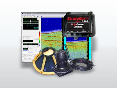
Acoustic Sub-Bottom Profiling (SBP) systems are used to determine physical properties of the sea floor and to image and characterise geological information a few metres below the sea floor. Sub-bottom profilers are usually comprised of single channel source that sends sound pulses into the shallow sub-sea floor sediments. The sound pulses bounce off the sea floor and subsequent buried sediment layers according to differences in their acoustic impedance (hardness).
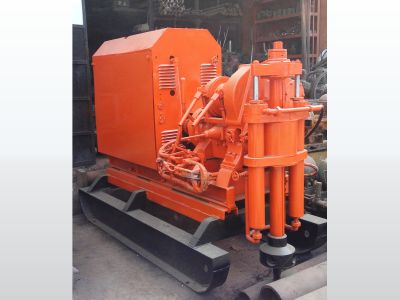
Voltas Rig is a Hydraulic Operated Skid Mounted Diamond Core Drilling Machines. It can be dismantled into various parts and easily transported on to a top of a hill
It is ideally suited for geotechnical investigation, core drilling, soil testing, soil investigation, dam foundation, tunnel drilling, mineral exploration, mine survey, geotechnical drilling for a depth of 300mtr.
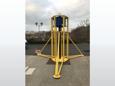
Vibrocorer has been designed as an easy to use, easy to transport modular system capable of collecting up to 6m cores in 250m water depth (max).
For use in dense/compact sediments in up to 250m water depth.
• Easy to assemble modular system offering cores of 3m or 6m system.
• Assemble dockside or on vessel, over stern deployment.
• High power vibrator motors engaged once unit is on the sea floor to drive the core barrel into the bed.
• Cutting shoe and core catcher specifically designed to minimise sample disturbance.
• Unit designed for easy horizontal recovery to the vessel, and easy recovery of the core on deck.
• System can be can be quickly and easily deployed, delivering a well-defined core.
• Steel elements hot-dip galvanized and stainless-steel construction.
• PVC Core barrel liner.
• 96mm diameter sample.
Acoustic Doppler Current Profiler (ADCP) is a hydroacoustic current meter similar to a sonar, used to measure water current velocities over a depth range using the Doppler effect of sound waves scattered back from particles within the water column. The device used in the air for wind speed profiling using sound is known as SODAR and works with the same underlying principles.
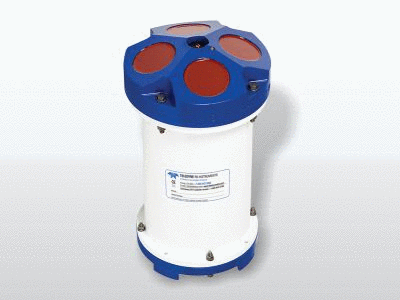
The CTD is perhaps the most commonly used tool in an oceanographer's armoury, providing detailed profile and time series data on the measured parameters Conductivity, Temperature and Pressure, but more particularly the calculated values of Salinity, Density and Sound Velocity.
Digital sampling techniques ensure high accuracy, and the unique construction gives sensor stability at any depth. Temperature is always measured with a fast response PRT (Platinum Resistance Thermometer), and instruments also use industry standard strain gauge or resonant quartz pressure sensors.
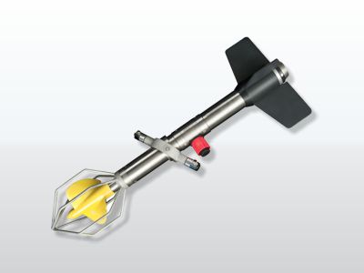
This is a lightweight alternative to larger flow meters, ideal for use in applications where the superior durability and depth rating of larger meters is not necessary. Utilising the standard 125mm diameter impeller, this Model features speed and direction parameters as standard, with further options of temperature and depth.
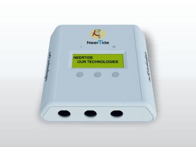
NeerTide is Nano, compact, handy and versatile easy to operate and simple to install radar-based tide gauge recorder for hassle free and accurate monitoring and recording of the tidal data. NeerTide is made up of components designed to withstand the marine environment and housed in ruggedized water proof case making it extremely portable.
NeerTide does not have any submerged sensors or moving parts in water thereby reducing the maintenance required. It can be used for permanent installation for port operations or can be used as a portable tide recorder for short term use.
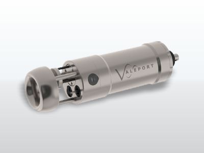
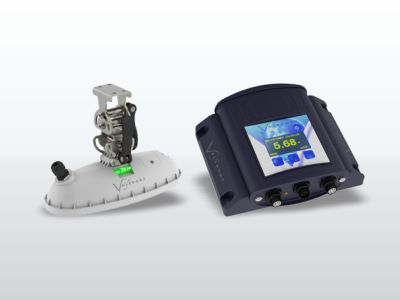
Sound Velocity Sensors and Profilers from Valeport, the world leaders in Sound Velocity technology – a position achieved by both innovative development and meticulous attention to detail throughout the design, manufacture and especially calibration processes. Having been established at the forefront of this field nearly a decade ago with Digital Time of Flight technology, Valeport have now made a series of incremental changes to reinforce that position, ensuring that Valeport SV sensors offer levels of performance that are demonstrably far in excess of even the latest offerings from our competitors.
A tide gauge is a piece of equipment used for measuring the changes in sea level with respect to a height reference surface. Although tide gauges have not been used as a primary source of sea-level data for several years, they play a key role in the instrumentation at modern-day tide gauge locations to verify water level.
A water sampler is often used in conjunction with a CTD. The water sampler collects 1 or more actual samples of water for analysis in the lab after recovery of the package. The water samples can be used to verify the accuracy of data measured by the instruments on the package, and/or to provide additional information that cannot be measured with an instrument in the field.
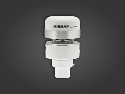
Weather Station (Airmar 110WX) accurately measures wind speed and direction, air temperature, barometric pressure and humidity in a compact platform with no moving parts and IPX6 waterproof rating.
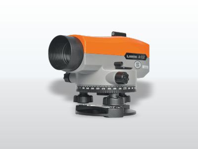
Auto level is an optical instrument used to establish or verify points in the same horizontal plane in a process known as levelling, and is used in conjunction with a levelling staff to establish the relative heights levels of objects or marks.
It is widely used in surveying and construction to measure height differences and to transfer, measure, and set heights of known objects or marks.
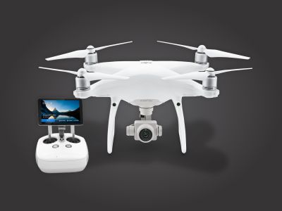
Professional surveying, geo mapping and asset inspection are dynamic processes, and the base for many engineering projects. The Phantom 4 Pro brings several improvements to the surveying industry by capturing data faster to generate accurate orthophotos, 3D models and point clouds in high density.
Efficient flight planning simplifies parameters essential for professional photogrammetry. UAV surveying has been proven to be faster, safer and more cost effective than traditional survey, making it the perfect addition to the traditional surveying equipment portfolio.
Phantom 4 Pro improves efficiency: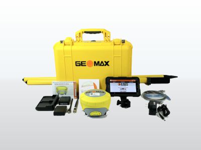
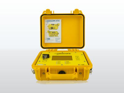
Real Time Kinematic (RTK) satellite navigation is a technique used to enhance the precision of position data derived from satellite-based positioning systems (global navigation satellite systems, GNSS) such as GPS, GLONASS, Galileo, and BeiDou. It uses measurements of the phase of the signal's carrier wave, rather than the information content of the signal, and relies on a single reference station or interpolated virtual station to provide real-time corrections, providing up to centimetre-level accuracy.
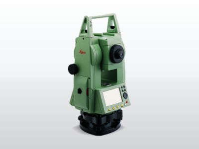
The Leica Geosystems TC305 is a high-quality electronic total station designed for the construction site. Its innovative technology makes the daily surveying jobs easier. The instrument is ideally suited for simple construction surveys and setting out tasks.
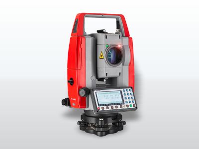
Pentax PCS-225 Electronic Total Station offers a complete selection of useful programs and measurement types while retaining simplicity of operation. The easy-to-read large LCD displays clear guide messages for each operation allowing even a non-experienced operator to be productive almost immediately. Fine distance measurements are a fast 2.0 seconds and tracking measurements are very fast at 0.5 seconds.
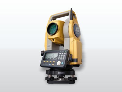
Designed for the Professional Surveyor, GTS-211D Total Station is ideal for any surveying application. Whether it be the tightest control survey, construction staking or boundary survey, with 2 second angular accuracy and its rugged design the GTS-211D is suitable for use in the toughest environments.
Topcon GTS-211D can stand up to any wet weather condition that can occur in the field. LCD displays on each side of the instrument means you can shoot reverse angles easily.
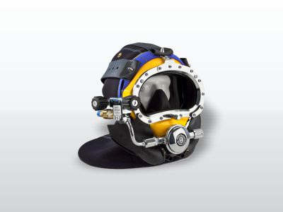
The fully tested and certified Band Masks used in mixed gas diving as well as shallow water diving. The adjustable demand regulators provide low inhalation resistance and high gas flow letting the diver breathe easier and work harder with less exertion. Both masks come standard with the large tube regulator.
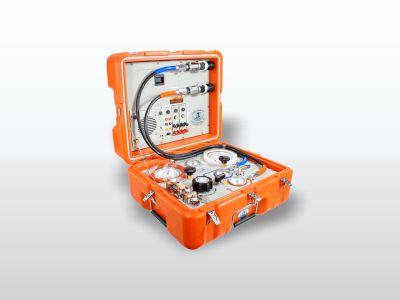
The Air Control Box controls diver’s air supply, communications, and monitors the diver’s depth. It allows two divers clear push to talk (two wire) or round robin (four wire) communications. The air supply can be either from a low-pressure compressor or high-pressure cylinders. The adjustable first stage regulator reduces the high-pressure air and supplies low pressure through the umbilical to the diver’s breathing system.
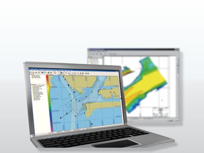
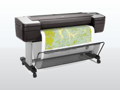
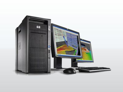
High configuration PCs for Design & Processing and Laptops for Data recording.